The earth is constantly moving under our feet, not every day but if you ever check the Pacific Northwest Seismic Network (PNSN) at pnsn.org you might be amazed at how much seismic activity takes place around us …or under us.
Recently the PNSN, at the University of Washington, along with their science partners the US Geological Survey, contacted the city of Forks proposing a two-month-long deployment of ground motion sensors at the Quillayute Airport.
The data collected will be used as the basis for a set of observational experiments. Seventy-five temporary seismometers spaced 150 feet apart will collect the data. The seismometers placed in late August are to collect data through the middle of October when they will be removed.
The experiments will have two major goals aimed at improving understanding of, and mitigation of earthquake hazards in western Washington.
The Cascadia Subduction Zone is a 600-mile fault that runs from northern California up to British Columbia and is about 70-100 miles off the Pacific coast shoreline. There have been 41 earthquakes in the last 10,000 years within this fault that have occurred as few as 190 years or as much as 1200 years apart. The last earthquake that occurred in this fault was on January 26, 1700, with an estimated 9.0 magnitude.
This earthquake caused the coastline to drop several feet and a tsunami to form and crash into the land. What is most surprising is that evidence for this great earthquake also came from Japan. Japanese historic records indicate that a destructive distantly-produced tsunami struck their coast on January 26, 1700. By studying the geological records and the flow of the Pacific Ocean, scientists have been able to link the tsunami in Japan with the great earthquake from the Pacific Northwest. Native American legends also support to the timing of this last event.
The data collected, from small earthquakes, will be used to better understand the threat the fault poses.
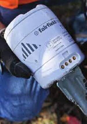
Each self-contained ground motion monitor is the size of a coffee can and will measure ground vibration. Each has a battery, memory to store the data, and GPS clock to record the precise time.
Data produced by the experiments will be made available to the public through the Incorporated Research Institute in Seismology Data Management Center.


